

Challenge
Protected areas worldwide face increasing pressure from habitat fragmentation, expanding human settlements, infrastructure development, and climate change. Wildlife managers require timely information on animal movement, habitat conditions, migration corridors, and potential human–wildlife conflicts to support conservation while safeguarding nearby communities. Conventional monitoring methods often depend on fragmented observations and manual reporting, limiting the ability to make proactive, science-based management decisions.
Solution
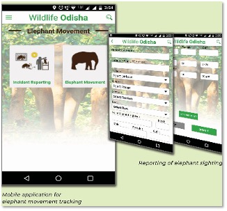
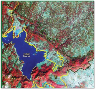
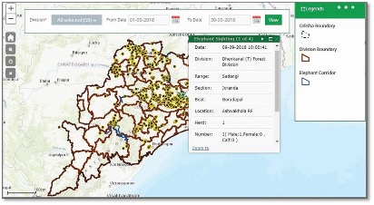
SPARC developed an integrated GIS-based Wildlife Decision Support System (DSS) for Chief Wildlife Warden Odisha that combines location-based wildlife tracking, satellite imagery, GIS, mobile field data collection, habitat mapping, and spatial analytics within a unified WebGIS platform. The solution continuously monitors the movement of elephants, analyzes habitat utilization and migration corridors, identifies conflict-prone locations, and provides real-time visualization, alerts, and decision-support tools for conservation agencies. Mobile applications enable field teams to collect geo-tagged observations, validate incidents, and synchronize information for centralized monitoring and coordinated response.
Outcome
The platform has strengthened wildlife conservation through continuous monitoring, improved habitat management, and faster response to potential human–wildlife conflicts. It has enhanced collaboration between field personnel and decision-makers, supported evidence-based conservation planning, and improved the protection of critical wildlife corridors and biodiversity-rich landscapes. Designed as a scalable geospatial platform, the solution can be adapted for monitoring diverse wildlife species, protected areas, ecological restoration initiatives, and conservation programs across different ecosystems worldwide.
Highlights
This project demonstrates how geospatial intelligence enables proactive wildlife conservation and sustainable coexistence between people and nature. By integrating location tracking, GIS, satellite monitoring, and spatial decision support, SPARC has created a scalable platform aligned with global conservation priorities, including biodiversity protection, ecological connectivity, and climate resilience. Although initially developed for elephant conservation, the architecture can readily support the monitoring of migratory mammals, endangered species, and protected landscapes in North America, Latin America, Africa, and beyond, making it a compelling example of digital innovation for conservation.
Relevant Industries / Sectors
- Wildlife Conservation
- Forestry & Protected Area Management
- Natural Resource Management
- Environmental Conservation
- Biodiversity Management
- National Parks & Protected Areas
- Climate & Ecosystem Resilience
- Government & Public Sector
- Environmental Consulting
- Research & Academic Institutions
- International Development Organizations
- Ecotourism
- Infrastructure & Environmental Planning
- ESG & Sustainability