30 Years of Engineering Excellence
Proven delivery of mission critical software and GIS systems across 500+ projects for 150+ customers worldwide.

Delivering innovative geospatial, software and digital transformation solutions
bringing impact to governments, enterprises & communities worldwide, since 1997.
Trusted by Governments, Global Enterprises and Fortune 500 Companies
Proven delivery of mission critical software and GIS systems across 500+ projects for 150+ customers worldwide.
One partner for enterprise software, geospatial intelligence, AI and cloud platforms integrated from day one.
Millions of land parcels, thousands of users, state wide deployments and mission critical operations.
Canada headquarters with worldwide delivery capability across five continents.
Cloud, AI, geospatial, satellite analytics, data and modern application development integrated for enterprise scale.
Artificial Intelligence becomes more valuable when combined with location. SPARC integrates GeoAI, computer vision, machine learning and satellite analytics to detect change, automate verification, predict outcomes and support evidence based decisions.
Manual crop verification slows procurement and increases the risk of ineligible claims.
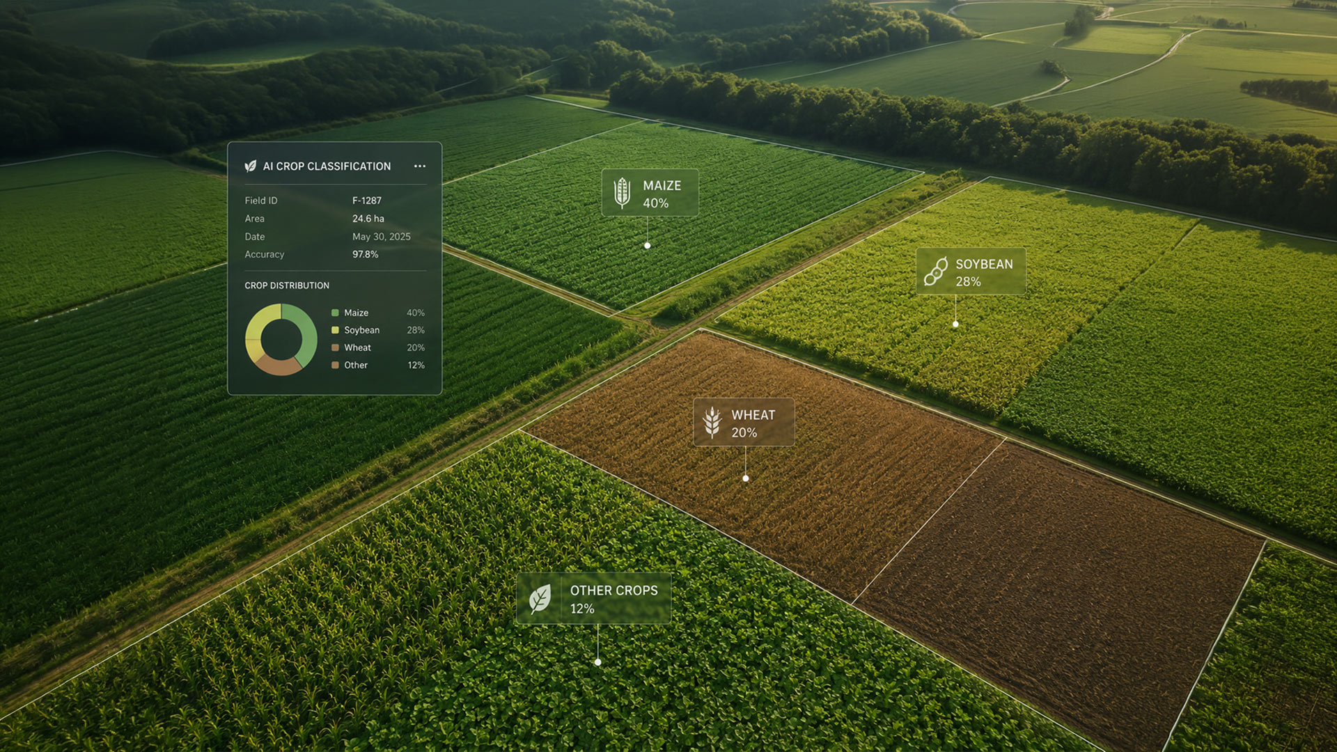
GeoAI-powered parcel-level crop validation automates eligibility checks using satellite imagery, GIS, and AI.
Manual surveys make it difficult to monitor large agricultural landscapes across multiple crop cycles.
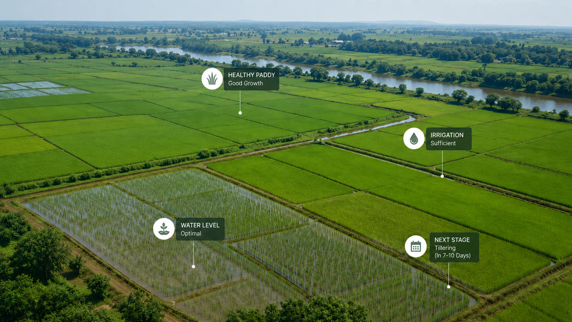
GeoAI-powered monitoring classifies crops, tracks growth & forecasts yields using satellite imagery.
Farmers and Water User Associations lack site-specific guidance on what to grow, where, and when.
GIS and satellite-based analysis recommends season-wise crop plans using land, soil, water, and market data.
Fragmented forest records and outdated maps hinder effective land governance and planning.
A unified WebGIS platform integrates forest records and spatial data for accurate, data-driven management.
Manual mine monitoring makes it difficult to detect illegal mining and lease violations.
AI-driven geospatial analytics enable real-time monitoring, compliance tracking, and evidence-based enforcement.
Unclear land records and inaccurate surveys delay urban planning and tenure security.
Drone-based GIS mapping creates a precise digital land inventory for transparent planning and redevelopment.
Siloed geospatial data limits collaboration and slows government decision-making.
A statewide Spatial Data Infrastructure delivers standardized, shared geospatial data through a single trusted platform.
Limited ecological insights make restoration planning and monitoring inefficient.
GIS and GeoAI identify restoration priorities while tracking progress through an integrated MRV platform.
Fragmented wildlife observations limit proactive habitat management and conflict response.
GIS wildlife tracking, habitat mapping, and mobile field data unify monitoring and decision support.
Fragmented environmental monitoring data limits hotspot detection and regulatory enforcement.
GIS integrates industrial inventories, monitoring stations, and spatial analytics for evidence-based environmental governance.
Manual permit processes and limited spatial analysis cause route conflicts and inefficient mobility planning.
Enterprise WebGIS digitizes permits, route planning, compliance checks, and real-time transport services.
Fragmented utility records make it difficult to locate assets, reduce losses, and serve customers efficiently.
WebGIS unifies distribution networks, customer connections, and operations into real-time utility intelligence.
Fragmented planning data and manual workflows slow scenario evaluation and cross-agency coordination.
WebGIS master plans integrate land use, transport, utilities, and regulations for evidence-based urban planning.
TerraScope vertical products deploy ready made intelligence or build on the platform.
Monitor crops, predict yield, and optimize procurement with satellite-verified intelligence.
ExploreEnd-to-end mine intelligence — production, compliance, ESG and volumetrics on one layer.
ExploreContinuous forest governance — deforestation alerts, carbon and conservation programs.
ExploreScalable, secure systems from concept to deployment cloud native and audit ready.
Learn moreGIS, remote sensing, drone analytics and spatial data infrastructure at enterprise scale.
Learn moreStrategic guidance to modernize operations with geospatial intelligence and cloud platforms.
Learn moreCanada headquarters with delivery and innovation across India, the Middle East, Africa and Asia-Pacific.
Helping governments and enterprises build climate resilient, responsible operations.
Protect ecosystems with continuous monitoring of forest health, biodiversity, and land use change.
Learn moreAnticipate climate risk and strengthen adaptive capacity with location-aware intelligence.
Learn moreMeasure, verify, and report carbon outcomes with auditable geospatial evidence.
Learn moreReduce environmental impact from exploration through closure and rehabilitation.
Learn moreOptimize inputs and yields with satellite monitoring and field-level intelligence.
Learn moreEnable transparent, accountable public programs backed by spatial data citizens can trust.
Learn moreExpertise on GeoAI, sustainable practices and digital transformation.
Whether you're modernizing government services, managing natural resources, or building intelligent enterprise systems, SPARC Global can help turn complex data into measurable outcomes.