The operational system of record for mining: pit, plant, port, and ESG. 6 integrated modules on one spatial data infrastructure. Drone and satellite fusion accuracy, audit-grade ESG, and chain-of-custody from pit to port
TRUSTED BY MINING INDUSTRY LEADERS
Mining operations run on fragmented data. Lease boundaries live in one system. Geological surveys in another. Production telemetry in a third. ESG reporting in spreadsheets. The site GM cannot answer simple questions in a single view: where is my disturbance footprint trending, are we within the lease, did the rehabilitation plan track this quarter, what is actually moving from stockpile to port.
MineScope unifies the spatial layer (geology, lease, land use, production, environment, workforce, logistics) into a single operational picture, with audit-grade telemetry the regulator and the auditor can both trust.
Transforming mining operations through intelligent technology
Automatically track permit and EIA conditions, detect land or water deviations, and produce audit-ready records at a greater frequency.
Stay ahead of compliance deadlines with proactive alerts and reduce penalty occurrence and consultant billable hours through real-time oversight.
Dynamically visualize your entire operation from pits and haul roads to stockpiles and water infrastructure in a singular view pulling live data from all of your departments.
Retrieve any map, document, or inspection record in seconds. Centralized search + citation tracking based on historical records and 3rd party partner cloud storage.
Eliminate manual GIS workflows by automating land-disturbance reconciliation, monitoring progressive reclamation, and increase team capacity without adding headcount.
Create regulator-ready reports and annexes with one click, each figure and table linked to its geospatial evidence and timestamped source for external sharing.
Six integrated modules solving your biggest operational challenges
Compliance checkmark—alerts, audits, & ESG in one frame
Integrates land, air, water, and tailings sensor data with satellite thermal and night-light imagery. Predictive AI (87% validated accuracy) forecasts compliance status 24–48 hours in advance, enabling early action before thresholds are exceeded.
From acquisition to rehabilitation—own every inch of your land data
AI-driven land monitoring that detects disturbance, encroachment, and unauthorized activity with 89% validated accuracy. Automated alerts and month-by-month satellite evidence deliver 60% faster land & R&R compliances.
Your Single Source of Authentic Data
Centralize all spatial and non-spatial data for a mining Project into a Central validated, sanitised and synchronised geo-database. Mines DI provides the data backbone where all spatial layers and tabular datasets reside with full traceability.
Workforce Mobility, Safety & Field Reporting—All in One
Advanced time-series AI (84% accuracy) predicts equipment failures before they happen. Real-time workforce tracking with geofencing and safety compliance. Drone-based stockpile volume estimation.
Track material flow from Pit to Plant to Port
Advanced multi-modal AI (80% precision) detects illegal mining activity using satellite, night light, and thermal data. Real-time GPS tracking with RFID gate data provides complete pit-to-port visibility.
From surface to subsurface—AI-powered geological intelligence
Unified drillhole database with core photo carousels, assay integration, 3D geological models, and resistivity isosurfaces. Includes business intelligence for exploration ROI and site selection.
Real-time visibility into all mining operations from a single dashboard
COMPLIANCE RATE
EARLY-WARNING ALARM
ACTIVE SENSORS
REPORTS READY
PM10 Early-Warning Alarm: Threshold breach predicted
Action: Execute Dust Suppression T.A.R.P.
RECOMMENDATIONS
Run Haul Road Dust Suppression on Day Shift for main ramp outside of pit.
Real-Time Sensor Network + AI Compliance Forecast
West Bokaro Mine | Updated: Oct 28, 2025 10:30 AM | Next forecast: 2:30 PM
PM10 Trend (Last 48h)
Agentic AI Forecast
• Next 12h: 85 µg/m³ (within limit) Confidence: 87%
• Next 36h: 105 µg/m³ (BREACH)
Machine-learning models flag likely air and water exceedances up to two days ahead with 87% proven accuracy. Automated data workflows generate OEFA/EC compliance reports within three days, reducing turnaround from weeks to hours.
EXAMPLE WORKFLOW:
AREAS MONITORED
CHANGES DETECTED
DETECTION ACCURACY
LAST SCAN
New disturbance detected - Zone B
Action: Field team dispatched for verification
RECOMMENDATIONS
Schedule immediate site inspection for Zone B encroachment
Prepare boundary violation report for regulatory notification
Change Detection - Before/After Analysis
Sentinel-2 10m Resolution | Mining Pit Expansion Monitoring
Satellite-driven analytics detect new disturbance and encroachment across the lease with 89% verified accuracy. Month-to-month change reports highlight possible violations ahead of regulator findings.
EXAMPLE WORKFLOW:
ACTIVE DATASETS
DATA QUALITY
API REQUESTS
STORAGE USED
New dataset published - Mining Lease Boundary v4.2
Action: All subscribed teams notified automatically
RECOMMENDATIONS
Review and approve pending dataset updates (3 awaiting approval)
Schedule metadata quality audit for Q4 2025
Unified Spatial Data Infrastructure
847 Active Datasets | ISO-Compliant | 100% Interoperability
Mines DI Database
Single Source of Truth
• 847 active datasets | 98% quality score | 12.4K API requests/day
• Latest update: Mining Lease Boundary v4.2 (2 hours ago)
Unified spatial data infrastructure provides single source of truth for all mining operations. ISO-compliant metadata, versioning, and seamless data sharing across departments with 100% interoperability.
EXAMPLE WORKFLOW:
MONITORED ZONES
ILLEGAL SITES DETECTED
DETECTION PRECISION
EVIDENCE KITS READY
Illegal pit detected - 500m NE of boundary
Action: Evidence kit generated - enforcement notified
RECOMMENDATIONS
Submit evidence kit to enforcement authority within 24 hours
Continue monitoring for expansion of illegal activity
Night Light + Thermal Analysis
October 27, 2025 | 03:20 AM UTC | VIIRS DNB + Landsat Thermal
• Illegal Pit: 680m E of boundary | Night light intensity: 85 nW/cm²/sr | Thermal anomaly: +12°C
• Illegal Camp: 60m W of boundary | Equipment heat signatures detected | Est. active excavation
Precision: 88% | Evidence Kit GeneratedAdvanced multi-modal AI detects unpermitted pits, camps, and haul roads using satellite, night light, and thermal imagery. 88% precision with enforcement-ready evidence kits generated within 72 hours.
EXAMPLE WORKFLOW:
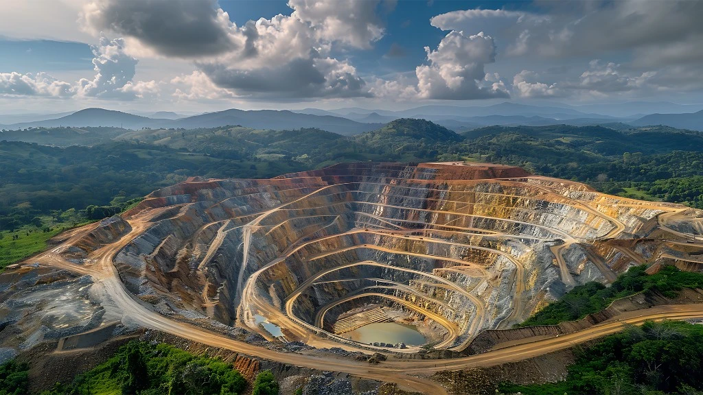
From initial exploration to final reclamation - comprehensive oversight at every stage
Geological surveys, mineral mapping, and site assessment using satellite data and AI-powered analysis
Advanced satellite imagery and AI-powered geological analysis accelerate exploration timelines while reducing environmental impact.
Real-time monitoring of extraction, processing, and logistics with integrated safety and efficiency controls
Integrated IoT sensors and predictive analytics optimize production while maintaining the highest safety standards.
Continuous compliance tracking, impact assessment, and ecosystem health monitoring through satellite surveillance
Automated satellite monitoring and AI-powered analysis ensure environmental compliance and rapid incident response.
Systematic site restoration, long-term monitoring, and sustainable land use transition with automated progress tracking
Continuous satellite monitoring tracks vegetation recovery and ecosystem restoration for sustainable land use transition.
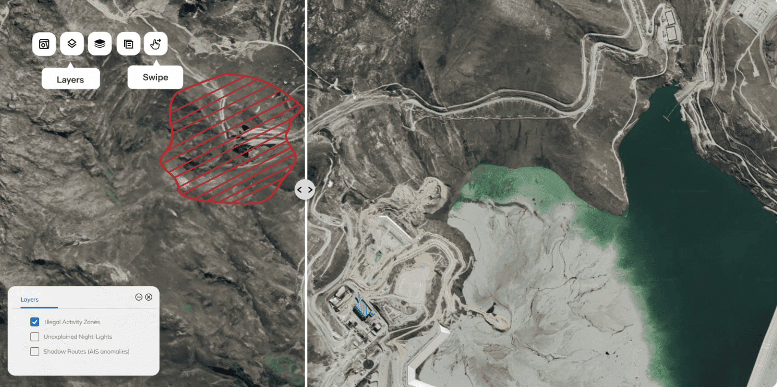
Satellite analytics identify new disturbance and encroachment across the lease area. Verified alerts enable teams to investigate and document actions before regulator inspections.
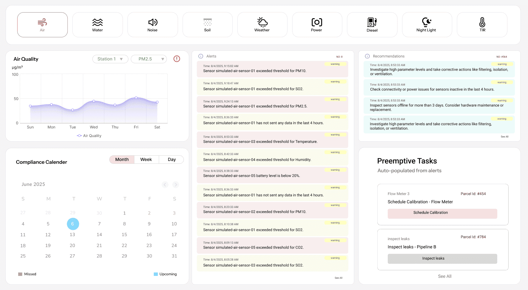
Monitor environmental parameters in real-time. Track air quality, water discharge, noise levels, and ensure compliance with permits and regulatory obligations.
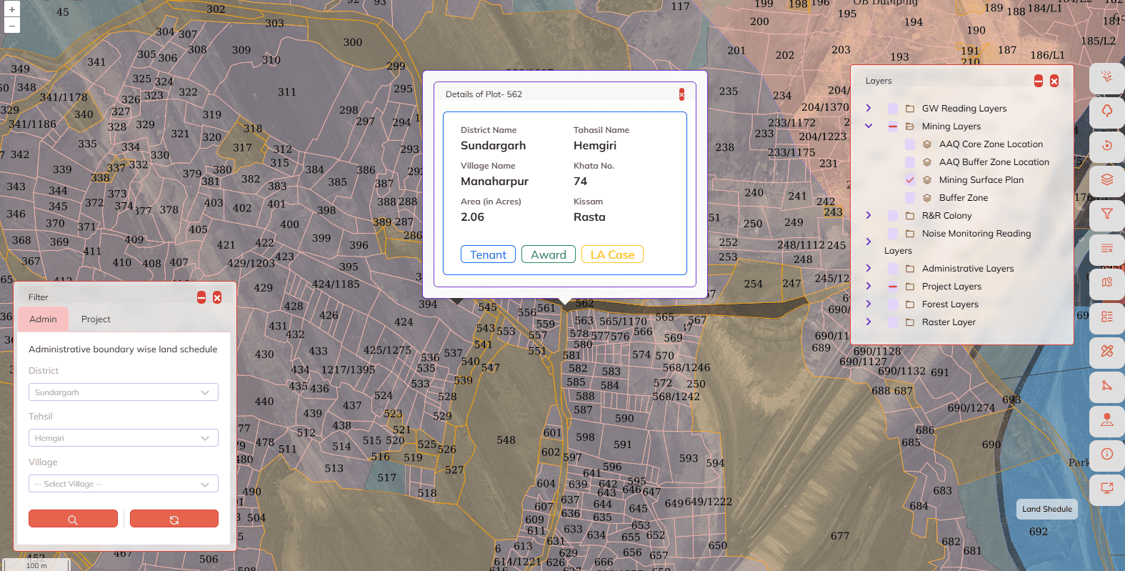
Comprehensive parcel registry with ownership details, boundaries, and R&R obligations. Complete land information system for mining lease management.
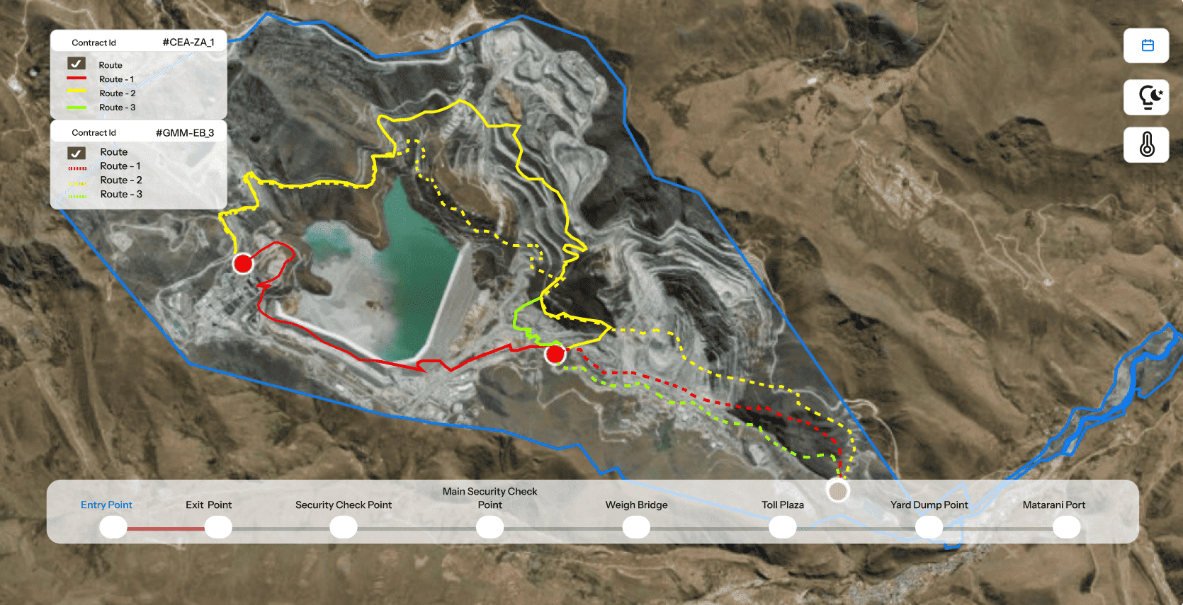
Track material flow from pit to port with GPS/RFID integration. Monitor chokepoints, optimize routes, and ensure complete traceability for compliance.
Custom professional services tailored to your mining operation needs
Complete migration to SDI framework including geo-referencing, transformation, sanitization, validation & integration of existing data to geo-referencing base
Development of comprehensive geodatabase with ISO-compliant metadata for spatial data management and interoperability
High-precision differential GPS survey including extension of national/state geo-referencing control to the project area
Professional digitization of existing maps and drawings with accurate geo-referencing and quality assurance
Generation of layout and topographic maps (roads, rivers, water bodies, drains, contours, overground utilities) through high-resolution drone surveys
Precise volumetric analysis for ore stacks, overburden, and mineral extractions, including bench slope analysis using drone survey data
Generation of temporal land use and change analysis using satellite remote sensing for compliance monitoring and environmental assessment
Custom web and mobile application development tailored to your specific operational requirements and workflows
Need a custom solution for your mining operations?
Request Service QuoteSee how leading mining companies use MineScope to transform their operations
Built for the most demanding regulatory environments
Certified
Information Security
Quality Management
Data Protection
IT Service Management
Capability Maturity